Monday, March 4, 2013

Backcountry Ice Climbing: AMG


Avalanche Mountain Gully
 
 
Avalanche Lake Panorama

Over the last few weeks Lukasz has been mentioning, on a daily basis, that he wants to hike into Avalanche Pass and do some ice climbing.  I felt like this would be a good experience.  I was up for a big day with a long approach, and an adventurous route.  I'm brand new to ice climbing and just bought ice tools about a month ago.  I have gotten out a handful of times, following friends on mostly WI4 climbs and even leading some easier lines.  Lukasz saw AMG (Avalanche Mountain Gully WI 4-) from across the lake while climbing the Trap Dyke last March, and has been set on climbing it since.
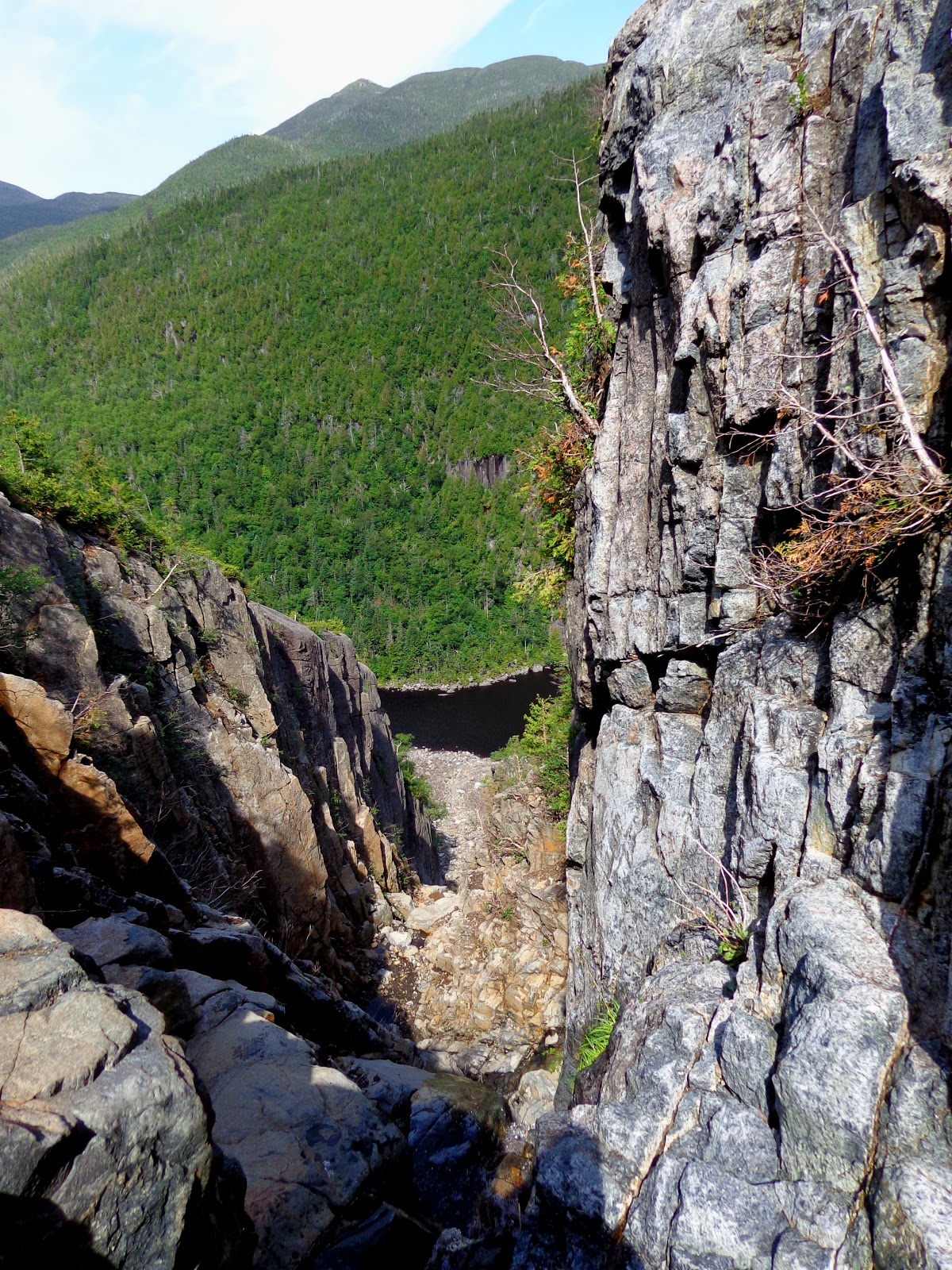

AMG

 
This picture was taken in March of 2012 with AMG in much fatter conditions than this year.  A recent trip report on Mountain Project indicated mixed conditions on the final pitch, which I think served to psyche Lukasz up even more.

Lucasz, Jackie and I began our day from the ADK Loj and followed well broken, moderate trails 5 miles in to Avalanche Lake.  An approach like this made us all wish we owned cross country setups, as skiers were constantly cruising by while we slogged our way in.  Weather conditions were fair.  The sky was 100% overcast with light snow falling on and off.  The temperature started in the mid 20s and dropped as we gained elevation.  The saving grace was the lack of wind which made the whole day a comfortable experience.

The Promised Land!
 
 
The route proper is approached from the west side of Avalanche Lake in between the wooden bridges (hitch up Matildas).  The first few hundred feet are a slow, steep wade, through deep snow slopes. 
 
The lower gully snow slopes
 
There is a short step (25') just below the actual climb.  This can be handled on easy WI3 to the left, or if you are feeling like a challenge, at its steepest section, which was fragile WI4.  Lukasz led this harder section and we all agreed at the end of the day that it was the pumpiest climbing we had done.  Given a second go, we would opt to take the easier path over and get to the main event above.
 

Beginning AMG
 
AMG's first pitch ascends increasingly steep ice, joining the huge left facing corner and continuing to an interesting cave belay.  The climbing is enjoyable and views of Avalanche Lake and the Trap Dyke make the setting of this climb very impressive.  We all had the feeling of doing something big in the mountains.  The acoustics of this area are strange.  Jackie and I could hear the crunch of footsteps and casual conversation of skiers hundreds of feet below us on the lake but communication with Lukasz above was nearly impossible, except for rope tugs.
 
Near the top of P1
 
Everyone made it to the cave without  incident. It was a little cramped for the three of us so I anchored in long with the rope and hung out on the small snow slope in front of the cave.
 
Jackie in the Cave
 
I was half scared and half psyched looking from the cave up the second pitch.  I had no doubt Lukasz would find a way to the top, and it just looked so cool.  What troubled me a bit was the giant free hanging curtain guarding the top out.  This pitch is near vertical right out of the cave, then eases up a bit in angle.  This leads to a thin mixed traverse behind the curtain and then up and over the fragile, barely attached ice to the top.  Lucasz did some serious whooping and sang the Polish versions of several classic rock tunes as he was clearly enjoying the climbing above.
 
 Leaving the cave. 
Hanging Curtain
 
As it turns out the climbing wasn't quite as difficult as I thought it would be.  There were great stances all the way up and the mixed traverse was exciting and interesting.  I'm finding that mixed sections really allow for a lot of creativity.  Lukasz and Jackie both made short work of the traverse, taking a low path and creeping up what turned out to be a short curtain of ice that was actually attached to the rock. 
Happy Jackie Sender
 
I on the other hand, made this traverse a bit more interesting.  I ended up climbing higher, all the way up to the roof.  After looking at the terrain I decided I was going to use a nice jug and just one tool.  Lukasz, who was belaying just to my right, was not giving me a single word of beta even though he saw me doing things differently.  I really appreciate this actually.  There is nothing worse than a climbing "coach" trying spray you down when you prefer to figure things out for yourself.  I thought I had clipped my second tool to my harness but I realized I had not when it began flying through the air, bouncing 300ft down the gully.  OOPS.  Luckily, my beta worked and I got through, topping out with one tool.
 
Missing a tool
 
Success!!! We spent a couple minutes on top celebrating and then it was time to get the flock out of there.  Three double rope rappels got us back to Avalanche Lake. We donned our headlamps for the last two as darkness was setting in.  Another two hours and we had dispatched the five miles of hiking back to the Jeep.  We ended up being out there from 9am until 9pm. A big day.  Absolutely worth it. One of the best days I've spent in the ADK backcountry.  Thanks Lukasz and Jackie. It was a blast!
 
Lukasz has a face.
 
Also: Special Thanks to Stewart's for hot dogs, chili, and, of course, coffee.


Saturday, March 2, 2013

Summer Highlights: Sugarloaf Mt.

Climbing Heros
 
 
Aerial photo of Sugar Loaf Mt.
 
 
Rock climbing at Sugarloaf Mt. has been somewhat of a secret.  Older climbers from the area know that this cliff was mentioned in one of Don Mellor earliest climbing guides.  It is mentioned briefly in subsequent books but not in any detail since the cliff is on private property.  Recently, this property was bought by the Nature Conservancy, and while technically climbing is still not allowed, this suggests that Sugarloaf will eventually become state land. 
 
This is an article from Adirondack Almanac explaining further on the land acquisition and the quality of the rock at Sugarloaf.


Now, fast foreword to July 2012.  I got a response to a partner search I posted on Mountain Project.  A guy from New Paltz wanted to come up and do some slab climbing in the Indian Lake area.  Sounded pretty cool.  I had a feeling he was talking about Sugarloaf.  The only reason I even knew the place existed was through another climbing friend, Mike Prince, who lives relatively close to the mountain and brought me there on a recon hike in the spring.  The slab is huge!  Basically it's the whole southeast face of the mountain.  Maybe a half mile wide and over 600 ft tall at its highest.  And it is STEEP slab.  Much steeper on average than say, the popular Chapel Pond Slab, for example.
 
It turns out that Mike from New Paltz had been visiting the cliff once or twice a year and is the primary route developer.  So our objective was this day was to add a final pitch to a previously established line called Heroes.  The original first 3 pitches were led on September 11th, 2011.  As we made our way up the route i noticed the rock quality was great and the pink veins of quartz running through the brown and grey stone were remarkable.
 
 
Hero's 200 ft corner
 
The first pitch was a bit scruffy but had an interesting set of moves none the less.  The second pitch brings you into the main feature of the route, a gigantic 200 ft left facing corner with a nice bit of crack climbing and a traverse.
 
The second belay
 
This is the belay at the base of the corner.  The trees are getting smaller.
 
Halfway up the corner on pitch three there is a ceiling that must be overcome. 


Directly behind Mike is the  pitch 3 ceiling.
 
 
After the ceiling nearing the top of pitch 3. 
 
Atop pitch three we reached the previous high point.  I could seee why the buck had stopped here!  Another ceiling guarded the last 50 foot of cliff to the top.  The problem was this.  The crack leading up to the right looked to be very steep and in the 5.10plus range.  The other option for the ceiling was to traverse in under the larger roof system from the left via a horizontal finger crack.  This also looked hard.  The majority of routes at this cliff a led in a ground up style with any protection (including hand drilled bolts or pitons) placed on lead.  Making these two options less likely because one never knows the difficultly of a section until it is climbed.  And yet there was a third option.  Creep up the roof's left side and follow a nice looking hand crack back to the right.  Not the most direct line but it look to be the easiest of the three.  Mike set out on lead.
Pitch 4
 
The climbing look reasonable enough as Mike went up.  He stood up around the left end of the roof and what looked like a nice yellow C4 hand crack turned out to be a chock stone at the bottom of a Bombay chimney that rises up and right over steep, slick, black slab.  Interesting.  There would be no pro for at least 20 ft as Mike under cling traversed this chimney up and right.  After backing off a couple times he went for it and after a few tense moments made it to easier ground and got in some gear.  He continued to the top of the route....What a lead!  Now he rated this pitch 5.7 PG.  After following I tend to lean more towards 5.8 PG/R.  A fall from the end of the run out section would be long, swinging and over a roof.   Regardless, sending it is certainly a rush!
 
After topping out this amazing route we set a top rope up to see just how hard the more direct variations were.
 
 
As we thought they were hard.  This photo is me TR'ing the direct finish.  A brutally pumpy crack.  The other variation follow the horizontal finger crack on the left.  This has now been led and goes at 5.9.  Harder if you have big fingers.
 
I was totally blown away by this cliff. There are already a dozen or so routes here with potential for many many more.  Eventually, I feel that Sugarloaf will become a destination cliff.  But for now it enjoys only a couple parties per season.  As it transitions to state land and becomes published traffic will increase I'm sure.  I am psyched to get back this coming season and try another route.


Friday, March 1, 2013

Gunks in February!


Gunks


February 26th? High of 45F? Rock Climbing? Gunks?
YES PLEASE!!
 
So after getting out on the ice a few times and ripping my hands up on plastic all winter long I was itching to get back on the rock.  Without knowing exactly what we would find I decided to call up Tina and head for the Gunks on Tuesday.  I pulled up to the Stairmaster at 900am and looked up to see dry rock and sunshine.  Sweet.  New Jersey commuters kept Tina from arriving until just about ten and by then I was about ready to sprint to the cliffs.
 
With the cool temps and having not been on the sharp end here since early November we decided to keep it tame tackling the classic Frogs Head first.  Turned out to be a nice climb with a bunch on thoughtful moves and an exciting finish for the grade.
 
Frog's Head


Moving on in my usual ravenous way about the Gunk I decided we would check out an easier route, another classic moderate  Arch.  Well this climb looks really cool and lives up to its name from the ground.


The route Arch wanders up from the left to the right and has an exciting exit right to a ledge before the top.  From here you are supposed to go right on easy climbing around a pine tree.  I didn't know this so I took on the crack left of the nine tree.  This was actually the crux of an intersecting route called Billy Shears but was well protected and over quickly.  Even if it was a full four grades harder than what I set out to do I have a hard time resisting good looking cracks.
 
A Grey Day

Next I wanted to step it up a little bit and do the first money pitch of Strictly From Nowhere.  The best part about February is no lines on the popular climbs.  Everything went okay here for me but Tina had to leave a cam I had slotted in the crux overhang section. This made for an interesting recovery with me having to climb back up to it on rappel. 
Tina Entering the Crux Section

I feel I should mention that cleaning gear is a skill that takes time to learn and master.  Sometimes panic sets in when a follow wants to send cleanly and they don't take the time to study the placement and how it went in.  People on lead with their own expensive gear will greatly appreciate a second who cleans well and will gladly give pointers on how to remove "stuck" or tricky to clean gear.  That shit is expensive! and we are not going home without it!!!

It was getting colder and we decided to make a slog for Limelight, a climb that caught my eye when I did Arrow a few month back.  The first pitch was good but nothing special and I really wanted to press on into that gorgeous white rock I knew was up above on P2.  Oh Well.  It was getting colder and we decided it would be easier to just set a TR up on P1 of Arrow and get to town for something warm to drink. 

All in all a great day with decent chilly temps on dry rock.  Rock climbing preseason season is upon us.
 

Summer Highlights: Trap Dyke

Trap Dyke Solo Mission

The base of the Trap Dyke
I havent had much of a chance to update in a while. In fact, I may have totally forgot I even had this blog.  Anyways, I'm not working this month and the weather outside leaves something to be desired.  Wet and rain and snow...tail end of ice season is upon us but early rock season is not quite here yet in the ADKS. 
 
One of my favorite days this summer was when i scrambled the Trap Dyke on Mt. Colden.  The Trap Dyke is a 2000 ft scramble with many 3rd class sections and a 4th class crux.  Considered to be one the Adirondacks Classic Mountaineering Routes. I came in from the ADK Loj and made the pleasant easy to moderate hike up to the scenic Avalanche Lake.
Avalanche Lake in July

Avalanche Lake is just so perfect, surrounded by steep rock walls and thick spruce, nestled between high peaks.  The hike around and bushwhack to the base to the Trap Dyke on the other hand, leave something to be desired but add the experience none the less.

Once inside this giant gully the temperature was nice and cool as i was out of the ever warming sun.  I should also note that the geological feature is caused by the differencial errosion of an igneous dyke surrounded by a much more weather and errosion resistant anorthosite.  Interesting.


This photo shows the difference between the white, gritty anorthosite above and the smoother igneous rock below.  As I climbed through the both sections I found the igneous rock to have great friction properties as well, even while I was wearing regular Merrell hiking sneakers.

As one gains elevation by climbing the route more and more spectacular views come into play.  About 30 minutes in one encounters a few rock steps waterfalls.  The highest been the 4th class crux.  Some parties may chose to rope up here and belay.  A small alpine rack of  a couple cams and nuts would be sufficient i think.  There is also a fixed piton there at the top of the waterfall.  Since Irene came through there are no trees at all for anchors.  The waterfall is certainly exposed and has a couple "moves" but they are simple enough and it is certainly a thrill.  I would suggest that someone wanting to attempt this climb be familiar with rock climbing or have experience on off trail scrambles with exposure.  A fall from the crux on the Trap Dyke could easily be fatal and was for one young man only a few seasons ago. USE CAUTION.

Above the crux

After the waterfall it becomes more pleasurable climbing all on easy rock.  Eventually, a large white slide of anorothsite intsects the dyke from the right.  This is the new exit slide formed by hurricane Irene.  I decided to throw on some rock climbing shoes I brought along just in case.  They arent absolutely necessary but I recomend something sticky because this is about 1000 ft of slab friction climbing leading almost directly to the summit.  The first and last 100 ft are the steepest and will get anyones attention.  They are avoidable if one wants to wade through krumbholz. But why do that?

view from the top

This shot shows the exit slide with Avalanche Mt, Algonquin and Wright Peak in the background.


more views from the summit of Colden

Notes

A rewarding view in every direction as Mt Colden has one of the more scenic ADK high peak summits.  After having a drink and a snack I decended via the Lake Arnold Trail which eventually led me back to Marcy Dam.

Round Trip was estimated at 12 miles with 3000+ ft of elevation gain.  PLEASE NOTE that these are my rough estimates and more accurate info from people who actually own and use a GPS can be found online.

Equipment consisted on a Camelpak with 3L resevoir. Snackbars. One pair of Merrell Moab Sneakers.  One pair of Scarpa Thunder Climbing Shoes.  Hiking Pants. T-Shirt. EMS TecWick long sleeve. Sunglasses. Headlamp.

Time car to car: 6 hours.


The TANK Boulder

Crazy Boulder Found


Last week a group of us were out exploring a new ice climbing area in the southern adks.  We were running around finding new ice lines like kids in a candystore. All of were pumped knowin that only a  handful of people, if anyone at all had been where we were.  As we explored a little more at the end of the day we turned a corner and saw the boulder pictured above.
 
The pic is a little distorted due to some snow on the camera lense but Lukasz in the frame provides some sense of scale.  This rock is a Tank! Literally. It extends 30 feet or more back out of the frame and the giant narrowing roof resembles the gun in front.
 
The facts that we were already thrashed from slogging deep snow and climbing steep ice....as well as not possessing any rock shoes meant we couldnt realistically try any problems.
 
Its a ways in the woods in a less traveled section of the adks but in non winter conditions the approach wont be too bad at all.  There were a couple small boulders nearby that promised decent lines as well. Further exploration to come.